10 · APP TOUR

X6 AI 4D app in action

Real screenshots from the Android app — dashboard, VOXEL 3D visualizer, AR SAR scanner, Chat X6AI v1.5 and Token Store.

01

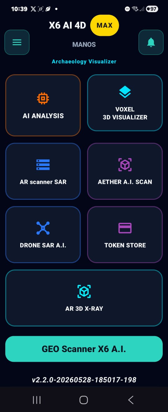
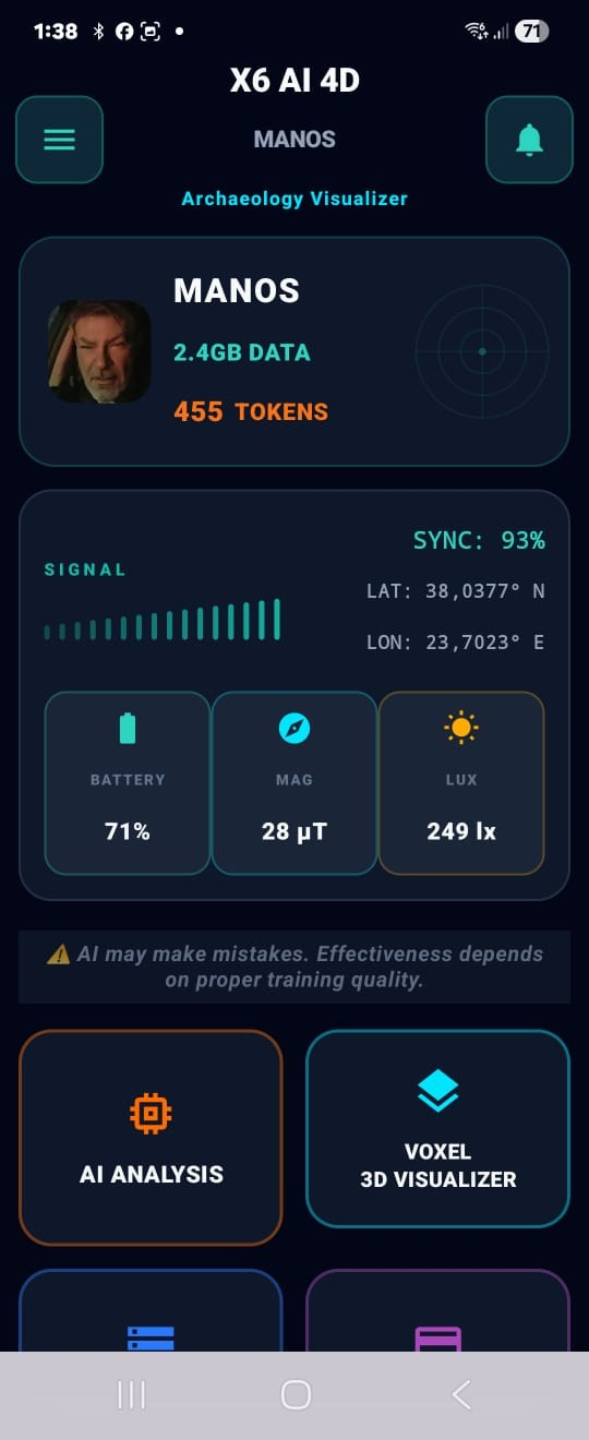
Home Dashboard — Archaeology Visualizer

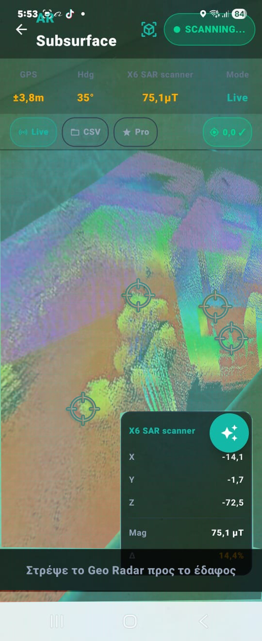
X6 AI 4D home screen with user profile, live sensors and one-tap access to every feature.

  • User profile with stored data and available tokens.
  • Live sensors: GPS (LAT/LON), battery, magnetometer (μT), lux meter, SIGNAL bars.
  • AI disclaimer — transparent about model accuracy.
DASHBOARD SENSORS GPS
02

Main Menu — All tools at once

One tap into AI Analysis, VOXEL 3D Visualizer, AR SAR scanner, Token Store and the GEO X6 A.I. Scanner.

  • Color-coded cards per function (orange = AI, teal = 3D, blue = SAR, purple = Store).
  • Primary CTA "GEO X6 A.I. Scanner" to start scanning instantly.
  • Footer with version, copyright Noetic Lab. Developers (KRASSAS GROUP), Made in E.U.
MAIN MENU GEO AI
03

Chat X6AI v1.5 — Specialist assistant

Chat with an AI assistant specialized in geophysical archaeology: GPR, MGRS azimuth, material differentiation on the magnetometer.

  • Suggested prompts for a quick start.
  • Topics: depth, material, azimuth, orientation.
  • File attachments via the paperclip icon (CSV/TXT/XML).
CHAT X6AI v1.5 GPR · MGRS
04

Grid Survey — Professional geophysical mapping

Manual capture on pre-defined grid with Voxler-style 3D heatmap real-time. When the X6 gradiometer connects, it becomes the primary source — phone magnetometer drops to auxiliary mode.

  • Pro Setup: define dimensions/step + cell-by-cell capture.
  • Per-line Ground Balance + Z-score smoothing (3σ outliers clipped).
  • X6 Gradiometer Primary Source · 491 samples · 0% CRC errors · live test verified.
GRID SURVEY 🧲 X6 PRIMARY Z-SCORE
05

Space Scan — 3D indoor mapping

WiFi/BLE beacon tomography in top-down radar view with PDR positioning + X6 magnetic voxel layer for indoor mapping without LiDAR.

  • Stealth scanning: passive WiFi/BT tomography, no connection to APs.
  • Multi-anchor trilateration with path-loss model + IMU step detection.
  • 🧲 X6 PRIMARY badge when connected — magnetic samples in 3D mapper.
SPACE SCAN 3D MAPPING WiFi+BT+X6
06

X-Ray Mode — Through-wall RF tomography

Your WiFi router becomes a passive RF source. RSSI variations reveal metal structures, wiring, pipes, cavities — through walls.

  • Passive RF source — no transmitter needed, fully legal.
  • 7-Verdict Mag+RF fusion: METAL · VOID · CONCRETE · WIRE · WATER · AIR · AMBIGUOUS.
  • Crosshair scanner cursor with live verdict + distance through wall.
X-RAY MODE PASSIVE RF 7-VERDICT
07

AR SAR Subsurface Scanner — Live

Live AR overlay of subsurface structure through the camera view. The lens becomes a window into the ground.

  • Live readings: GPS (±23.9m), Heading (295°), magnetic field (74.5μT).
  • Modes: Live · CSV export · Pro features · Set 0,0 calibration.
  • Data panel with X/Y/Z coordinates and real-time Δ change.
AR SAR LIVE · SUBSURFACE X · Y · Z
08

VOXEL 3D Visualizer — AI scan analysis

Full 3D visualization of the subsurface with iso-surfaces and material separation (metals, strata, rocks, voids, anomalies).

  • Per-category metrics: PTS, MET, STR, ROCK, VOID, ANM with color codes.
  • VOL/3D toggle · filters ALL · MET · STR · ROCK · VOID.
  • rot (rotation) & RST (reset) buttons for easy 3D navigation.
VOXEL 3D ISO-SURFACE AI DETECTION
09

VOXEL Controls — Colormap & Rendering

Full rendering control: palette choice, slicing on X/Y/Z axes, ISO threshold and opacity tuning.

  • 8+ colormap palettes (JET Standard, thermal, grayscale and more).
  • Slicing on all 3 axes with a 0-100% slider.
  • ISO threshold (65%) and Opacity (80%) with real-time preview.
SLICES ISO · OPACITY JET PALETTE
10

Token Store — GeoScan Credits

Buy credit packs from inside the app: Basic (5 tokens/€25), Pro (20/€80), Gold (50/€160).

  • Current balance ("Your credits: 100") always visible at the top.
  • No expiration — use whenever you want.
  • Secure checkout, instant crediting to your account.
TOKEN STORE BASIC · PRO · GOLD
APP WORKFLOW

From raw file to actionable report

The production workflow used by field teams in ScanAnalyzer.

Import scan files

Load CSV/TXT/XML/JSON files from GPR, magnetometers, MT systems, or mixed sensor exports.

Run AI analysis

Multi-engine AI estimates depth, material class, confidence and anomaly type.

Visualize in 2D/3D/AR

Switch between heatmap, profile, voxel cube and tactical AR HUD for spatial validation.

Review and collaborate

Keep every run in history, compare sessions, and answer follow-up questions in Chat X6AI.

Export and share

Generate PDF reports and share through secure operational channels.

OPERATIONS & SUPPORT

Built for real-world field lifecycle

Not just scanning: full operational continuity before, during, and after mission execution.

Unified analysis history

Single timeline for AI chats, voxel analyses and scans with rename, delete, and grouped report export.

Support tickets with threaded replies

In-app ticketing with priorities, admin responses, and closed/open state tracking.

Redeem code onboarding

6-character redemption flow that applies profile fields and tier safely with upgrade-only rules.

Version and update visibility

Users can check new versions directly in app and keep mission devices aligned.

Training-base integration

Merge multiple CSV/TXT/XML files into normalized datasets ready for training pipelines.

DATA & COMPLIANCE

Security, consent and commercial control

Enterprise readiness for protected data and regulated operations.

Data ownership by design

Field files remain user-controlled and can be reviewed, renamed or deleted at any time.

Explicit consent gates

Terms and privacy acceptance are captured before activation and payment-critical actions.

Device activation lifecycle

License and token activation are tied to the device flow with clear state transitions.

Secure token commerce

Token packs and activation handled through secure checkout with server-side validation.

CAPABILITIES MATRIX

Which modules solve which mission

Practical mapping by vertical so teams can select the right workflow quickly.

Archaeology

Modules: STR/VOID filters, stratigraphy view, AI chat interpretation, PDF reports.

Outcome: Reduced exploratory excavation and higher confidence in target zoning.

Mining

Modules: MET/ROCK discrimination, geological sync, 3D voxel density analysis.

Outcome: Fewer false positives and better drilling prioritization.

Defense / Government

Modules: Tactical AR HUD, multi-node fusion, support workflows, activation controls.

Outcome: Faster deployment with stronger operational accountability.

Research / Academic

Modules: integration tools, reproducible exports, historical comparison, AI evidence factors.

Outcome: Better reproducibility and publication-ready evidence trails.

LIVE TACTICAL SIM

Δοκίμασε το Tactical AR HUD

Διαδραστική προσομοίωση της πραγματικής εφαρμογής — Gun Scope reticle, Magnetic DNA Signature, 3-Phase State Machine.

X6 Subsurface 4D
0
● ΣΑΡΩΣΗ ● MOTION ⚫ MAN ΕΔΑΦΟΣ
GPS12sat · H1.20
RTKΕΠΙΒΕΒΑΙΩΘΗΚΕ 74%
ΔB+45.6 µT
MAG SONAR GPS SIG GPR-EXT AI
µT TRACE
ΥΠΟΓΡΑΦΗ DNA 0%
VOXEL 3D SIM

Εξερεύνησε το 3D Voxel Cube

Φιλτράρισε ανά κατηγορία υλικού (MET / VOID / ROCK / STR / ANM) — όπως στον πραγματικό VOXEL 3D Visualizer.

AI ANALYSIS SIM

Multi-Agent Flow σε Δράση

Παρακολούθησε τους AI Agents να συνεργάζονται σε real-time — physics, sonar, RF tomography, fusion engine.

📂 📂 Scan_2026-04-30_T01.csv → uploaded
Physics
µT + FWHM
Sonar
Multi-echo
📡
RF Tomo
X-Ray Mode
🧠
Fusion
ToF Engine
T01 · Underground-Crypt 99%
[ΚΕΝΟ] · CAVITY_WAVEGUIDE
Βάθος
~3.76 m
ΔB
−42.6 µT
DNA
DIP/VOID
RF Att.
+5 dB
DETAILED CAPABILITIES

How the application works

From raw electromagnetic data to a high-resolution geological X-ray — without pointless excavation.

Core Capabilities

3D

3D Voxel Imaging

The application converts the signals received from the GPR or gradiometer into a three-dimensional model of the subsurface.

  • Volume Analysis: It does not show just a «photograph» — the user can rotate the model and inspect the depth, shape and volume of the object.
  • Voxel Technology: Uses three-dimensional pixels (voxels) to render material density with high accuracy.
AI

Artificial Intelligence & Filtering (AI Filtering)

Perhaps the most powerful feature of the application is its ability to separate «noise» from the actual target.

  • Mineral Rejection: The AI recognizes the soil composition (e.g. high iron or salt content) and «removes» it from the image so it does not produce false signals.
  • Automatic Target Recognition: It can classify findings into Voids (caves, tunnels, tombs) or Metals (gold, silver, copper).
DEPTH

Depth Analysis & Stratigraphy

Precise depth measurement and visualization of soil layers — from soil to bedrock.

  • Exact Depth Calculation: The application calculates with centimeter accuracy the point where a target begins and where it ends.
  • Stratigraphic Imaging: Allows the geologist or researcher to see the different soil layers (e.g. soil, rock, sand) and any disturbances that indicate human intervention (e.g. backfilled openings).
GRID

Grid Survey — Voxler 3D Heatmap

Professional geophysical mapping over a pre-defined grid. You set dimensions and step, walk cell-by-cell, and the app builds a real-time 3D Voxler-style heatmap of magnetic anomalies.

  • Cell-by-cell manual capture with amber 🎯 GROUND BALANCE on the first cell of each line — eliminates ground drift.
  • Vertex mesh with Z-score smoothing (σ=2.0), Phong shading, Sci-Fi Fresnel halos on strong cells, magnetic particles. Drag = orbit, pinch = zoom.
  • Tiered billing: 1 token ≤200m², 2 tokens ≤400m², 3 tokens ≤600m², 5 tokens ≤1000m², 1 token/200m² above. CSV to Downloads/X6 AI 4D/DATA/.
FREE

Space Scan — Indoor Mapping (FREE)

Free local indoor mapping with passive WiFi RSSI scan + Bluetooth beacon listening + IMU dead-reckoning. Zero cloud calls, zero tokens. Works without GPS.

  • PDR (Pedestrian Dead Reckoning): magnetometer + accelerometer + gyroscope fusion. Step detection at 2 Hz, position update 1 Hz.
  • Auto anomaly pinning from AR Scanner findings + voice notes (long-press 🎤 for 30s recording → auto-transcription).
  • Multi-survey ICP merge + KDE treasure probability heatmap. Breadcrumb return arrow for quick exit. CSV export locally.
LIVE

Real-Time Processing Tools (Live Mode)

Live streaming analysis during fieldwork, without waiting for post-processing.

  • Wireless Streaming: Data is transferred via Bluetooth 6.1 directly to the application, allowing the user to see the analysis while walking the field.
  • Point-to-Point Analysis: Ability to focus on a specific point of the scan for further processing without needing a new acquisition.
EXPORT

Data Export & Reports

Professional output for documentation, mapping and continuation of study in external tools.

  • Geo-Tagging: Linking measurements with GPS coordinates for precise localization on the map.
  • Export Formats: Ability to export analyses in file formats compatible with other geological programs for further study.
PRIVACY

Data Ownership & Privacy

The company keeps no files on its servers — not even the survey areas. All data remains exclusively on your device.

  • Zero-server policy: zero storage of scans, GPS coordinates or reports on company servers.
  • Full control: revoke, rename or delete any analysis whenever you decide.
  • Local-only storage: all data stays on your device's internal storage.

The application essentially «makes the invisible visible», eliminating pointless excavation. It is a tool that turns raw electromagnetic data into a clear, high-resolution geological X-ray.

Online Integration

Real-Time Weather Integration

The application connects automatically to weather stations at the time of scanning, recording humidity, temperature and barometric pressure.

  • Atmospheric & Soil Humidity Levels Humidity directly affects soil conductivity and the propagation speed of radar waves. Recording it allows the AI to automatically calibrate the data for greater accuracy.
  • Temperature Helps analyze the thermal behavior of metals and voids, since temperature differences affect EMF sensor readings.
  • Barometric Pressure Important for detecting deep cavities, where pressure differences may indicate the presence of air or water.

Automatic Soil-Type Recognition (Geological Institute Sync)

Through online sync with international and local Geological Institutes, the application provides a full geological identity of the field.

  • Geological Mapping Automatically recognizes whether the soil is granite, limestone, clay or sandy, drawing data from official geological maps based on the GPS coordinates of the scan.
  • Penetration Adjustment (Dielectric Constant) The application «reads» the rock type and automatically adjusts the dielectric constant, letting the device know how easily or with how much difficulty the signal penetrates that specific ground.
  • Natural Mineral Flagging Notifies the user about the possible existence of natural deposits in the area, so they are not confused with the actual targets (e.g. iron veins or mineral-bearing rock).

Why these additions are critical

Error Reduction

The application «understands» the environment. If the ground is too wet due to recent rain, the software warns you or adjusts its filters.

Professional Reports

Every saved scan now includes a «Field ID» (Weather & Soil ID), which is essential for archaeological and professional geological studies.

Full Automation

The user does not need to enter the soil type manually. The application already knows it through the connection with the institutes.

🟦 Grid Survey

Professional Geophysical Mapping

Set dimensions + step — the app builds a 3D Voxler-style heatmap in real-time.

06:21 ΣΑΡΩΣΗ ΓΚΡΙΝΤ 📶 80%
14/25 cells
+8.4 ΔB
REC
-100+10 µT
+10 0 -10
14/25 · 491 samples · 0.8 m² · 300×300 cm
📌
ΓΩΝΙΑ
ΛΗΨΗ
ΑΠΟΘ.
📡 STEP 1
Manual Capture · Z-Score Smoothing Tap CAPTURE in each cell, app filters EMI spikes with rolling 30-sample Z-score window (3σ threshold).
🎯 STEP 2
Per-Line Ground Balance Amber 🎯 on first cell of each line — calibration per row to eliminate drift from geomagnetic field.
🌐 STEP 3
X6 Gradiometer Primary Source 491 samples / scan with 0% CRC errors. When the Subsurface Scanner connects, phone magnetometer drops to auxiliary mode.
See Grid Survey page →
🗺 Space Scan

3D Indoor Mapping without LiDAR

WiFi/BLE beacon tomography + X6 magnetic fusion + PDR positioning for indoor mapping without specialized hardware.

06:21 ΣΑΡΩΣΗ ΧΩΡΟΥ 📶 80%
⚡ 12/s
📡 18
🧊 142
🧲 491
AP-A8F2 BLE-BT 📍 ORIGIN
Voxels Beacons X6 Anchor
▶ START SCAN
📡 RF TOMOGRAPHY
Passive WiFi/BT Tomography Stealth scanning of surrounding APs/beacons without connection. Trilateration with path-loss model + multi-anchor calibration.
🧲 X6 MAGNETIC FUSION
X6 Magnetic Voxel Layer When X6 is connected, magnetic samples feed the 3D Voxel mapper with their own layer (🧲 X6 PRIMARY badge).
📍 PDR + SLAM
Pedestrian Dead Reckoning IMU step detection + magnetometer heading + EKF fusion. Works even without GPS inside building/tomb.
See Space Scan page →
📡 X-Ray Mode

«See» through walls with passive WiFi

Your WiFi router becomes a passive RF source. RSSI variations reveal metal structures, wiring, pipes, and cavities.

06:21 📡 X-RAY MODE 📶 80%
📶 ROUTER · -42dBm PASSIVE RF
🔩 METAL PIPE 🕳 CAVITY ⚡ WIRE 🟫 BEAM SCAN
METAL
VOID
CONCRETE
WIRE
RSSI Δ -8.4dB · 7-VERDICT FUSION · 4 OBJECTS DETECTED
📶 PASSIVE RF SOURCE
WiFi Router as RF Source No transmitter needed. WiFi signal propagation provides 'illumination' for RF tomography — fully legal and passive.
🔩 7-VERDICT MATRIX
Mag + RF 7-Verdict Fusion Combines RSSI deltas with magnetometer for 7 verdicts: METAL, VOID, CONCRETE, WIRE, WATER, AIR, AMBIGUOUS.
🌐 SEE-THROUGH-WALLS
Through-Wall Visualization Crosshair scanner cursor shows live verdict + distance through wall. Perfect for utilities, archaeology, security.
See X-Ray Mode page →